Ask the expert: How can the Chignik, Alaska, earthquake help predict future risk?
Article Highlights
- Earthquakes are caused by the movement of the tectonic plates that make up Earth’s crust.
- The Chignik, Alaska, earthquake on July 29, 2021 registered an 8.2 in magnitude — the largest earthquake within U.S. territory in 58 years.
- MSU Professor Jeffrey Freymueller is researching this earthquake to learn more about where, and how much plate slip occurred, to better understand how faults work and to help evaluate the risk of future earthquakes and tsunamis.
“Ask the Expert” articles provide information and insights from MSU scientists, researchers and scholars about national and global issues, complex research and general-interest subjects based on their areas of academic expertise and study. They may feature historical information, background, research findings or offer tips.
Earthquakes are caused by the movement of the tectonic plates that make up Earth’s crust. Off the coast of Alaska, the Pacific plate thrusts underneath the North American plate create enormous pressure at the Alaska-Aleutian fault. Between 2020 and 2021, the two plates slipped along this fault, producing a series of earthquakes, including the Chignik, Alaska, earthquake on July 29, 2021, which registered an 8.2 in magnitude — the largest earthquake within U.S. territory in 58 years.

Jeff Freymueller, Endowed Chair for Geology of the Solid Earth in MSU’s Department of Earth and Environmental Sciences, is an internationally recognized expert in geodesy, or the study of Earth’s size and shape. Courtesy photo
Jeffrey Freymueller, a professor in the Department of Earth and Environmental Sciences (EES) in the College of Natural Science at Michigan State University, is researching this earthquake to learn more about exactly where that slip occurred (and how much) to better understand how faults work and to help evaluate the risk of future earthquakes and tsunamis. Freymueller is an internationally recognized expert in geodesy, or the study of Earth’s size and shape, and serves as MSU’s Endowed Chair for Geology of the Solid Earth and EES department chair. This research appeared recently in the journal Science Advances.
What are the challenges with studying the Alaska-Aleutian fault?
The biggest challenge is that the fault comes to the surface on the ocean bottom far offshore, and there are kilometers of water in the way! We need to measure how the Earth was permanently moved by the earthquake, and we really need measurements that are made right above the part of the fault that slipped.
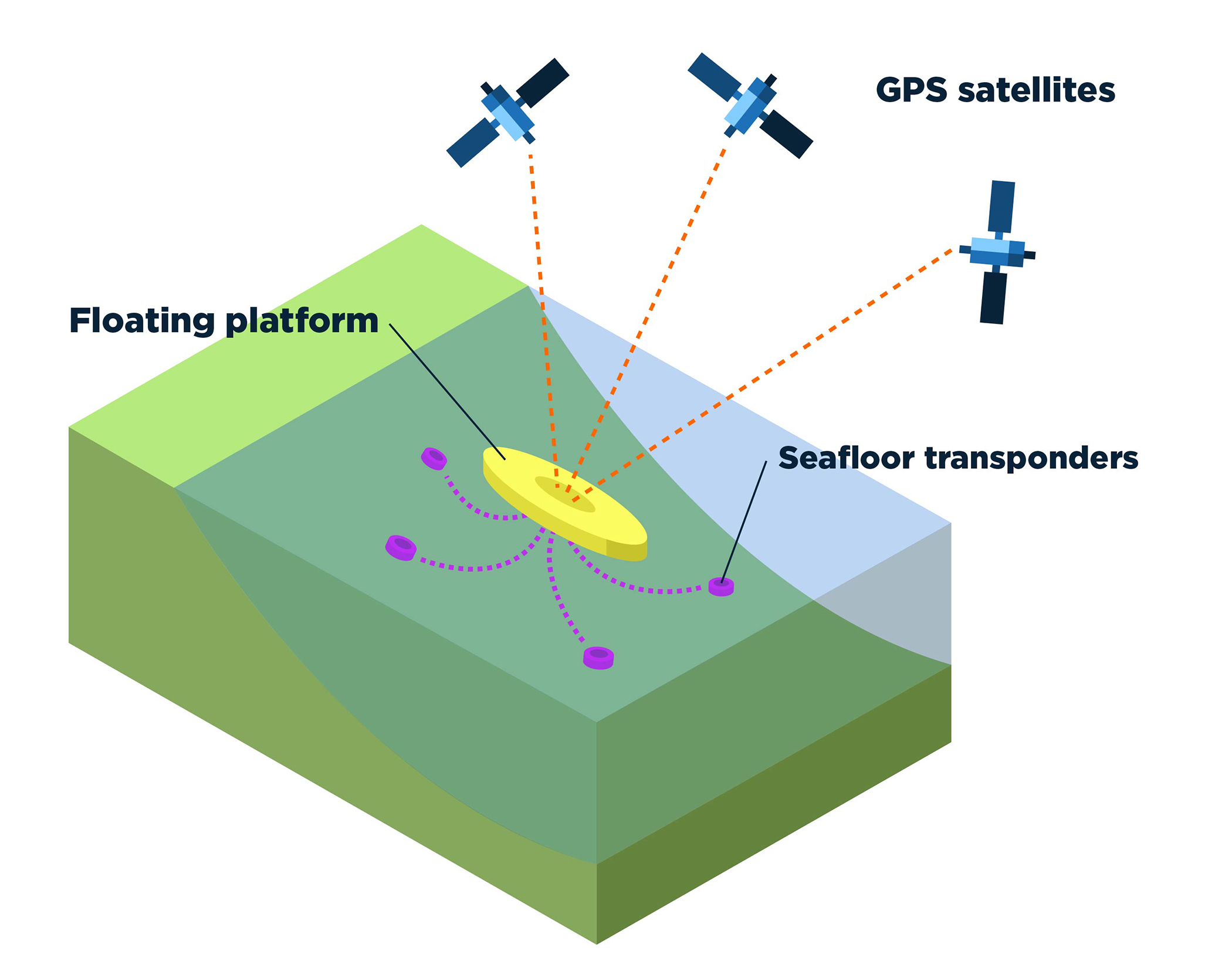
To measure earthquakes underwater, researchers must combine data from satellites in the sky with signals from transponders on the ocean floor. Credit: May Napora
On land, we can set up Global Positioning Systems or Global Navigation Satellite Systems — GPS and GNSS, respectively — instruments that measure and record the positions of the plates fairly easily, but the part of the fault that slipped in the earthquake is located pretty far away from land. Radio signals from the GPS satellites will not travel through water, so to get any data we must combine the GPS positioning of a floating platform with acoustic, or sound wave, positioning of the same platform relative to an array of transponders, which pick up and emit signals on the seafloor. This technique is called GPS-acoustic positioning. By repeating the survey measurements before and after the earthquake, we can measure how much the seafloor moved, and use that to better determine how the fault moved.
Why is studying the Chignik, Alaska, earthquake important to earthquake research?
The most important thing we learned is that the total movement at the GPS-acoustic site offshore was much larger than had been predicted by earlier models for the earthquake. Large earthquakes are important to study because they produce the largest motions and cause the largest changes in stress within the Earth. That means a large signal for us to measure, which is always helpful. The GNSS-acoustic position measurements of the seafloor’s motion are quite noisy because the speed of sound through the water is very sensitive to ocean temperature and varies a lot with time. That means it is hard to measure the acoustic range as precisely as we can measure the GPS part. So, it helps to have a larger motion to measure when the noise level is high.
How does this research help with assessing tsunami hazard risk?
This research helps with assessing hazard and risk. One of the interesting features of this earthquake is that it did NOT generate a large tsunami. Why didn’t it? The reason is that most of the slip on the interface between the plates happened only on the part of the interface that was still quite deep — the earthquake didn’t rupture to the seafloor or even close to it.
But we really need to know how close to the surface it got, and whether the shallower part of the fault that didn’t slip in this earthquake is capable of doing so in the future. If it is, then the risk of a future large tsunami is high. If the shallow part of the fault just doesn’t slip in earthquakes, but instead creeps along steadily, then the risk of a large tsunami from this part of the fault is much lower. We are still not sure, but now we know more than we did before about what happened in the earthquake. We’re continuing to look at other data, and we hope we will get more GPS-acoustic data as well to figure out how the shallowest part of the fault behaves.Banner image: Temporary global positioning system, or GPS, site in the Shumagin Islands, Alaska. Credit: Jeffrey Freymueller